The last government decided to split the four hundred year old city into North and South Dhaka. The original decision had some merit to it. Dhaka is enormous in terms of population and complexities. The greater metropolitan area hosts about 25 million people (2024 estimate), which is comparable to Norway, Finland, Ireland, Denmark and Croatia’s total population put together! It makes sense to decentralise it, and distribute the responsibilities and funds half and half.
Although, I think, drawing the border line horizontally, and splitting the city by North and South was not the best idea. It could have been drawn vertically making East Dhaka and West Dhaka instead! Since, practically, that’s how Dhaka is divided.
It is a gross generalisation, however, unless there is any active physical planning intervention, cities that starts near a river or a coastline, generally grows radially. One great half-circular thoroughfare gets added one after another crisscrossed by radial streets loosely pointing towards the centre. In the early days of Dhaka, that somewhat was the case—organically grown neighbourhoods by the river, time to time got connected by an overarching road on the North, like the Mitford Road, Bangshal Road, Lalbagh Road connecting from East to West. Thus the city kept growing North.
This northern motion gained momentum, also due to the geographic limitations of Dhaka being an island stretched vertically towards the North on the map. That necessitated the later creation of major thoroughfares all the way towards Tongi and Gabtoli. Meanwhile, this phenomenon broke the semi-organic gradual addition of new semi-circular East-West connections. One after another major thoroughfares were built that connects North and South like Progoti Sarani, Gulshan Avenue, Airport road, Kazi Nazrul Islam avenue, Rokeya Sarani, Kamal Sarani, Mirpur Road, Sat Masjid Road, Gabtali-Sadarghat Road. While uninterrupted East-West connection remained almost non-existent. This makes a long North-South journey from Tongi to Supreme Court easier than going a small distance East-West from Gulshan to Dhanmondi.
While this ‘island effect’ pushed Dhaka upwards, however, due to illegal occupation of wetlands by Bashundhara, government funded Purbachal and other land grabbers on the Eastern side made an eastern expansion viable. And it is visibly happening, along with some major eastward connections like the so called 300 feet and 100 feet roads (sad that these roads do not have any better names!). However, that too only starts from Gulshan edge of the city, and physically stops when it hits the river on the East.
Some Easy Ideas for Improving East–West Connectivity
Many of the potential East–West connections are interrupted often abruptly. There are some incredibly simple and obvious opportunities of building better East-West connections in Dhaka by making these reasonable connections, much like what happened with the demolition of old Rangs Building for creating the Bijoy Sarani–Tejgaon link road. Here are some ideas:
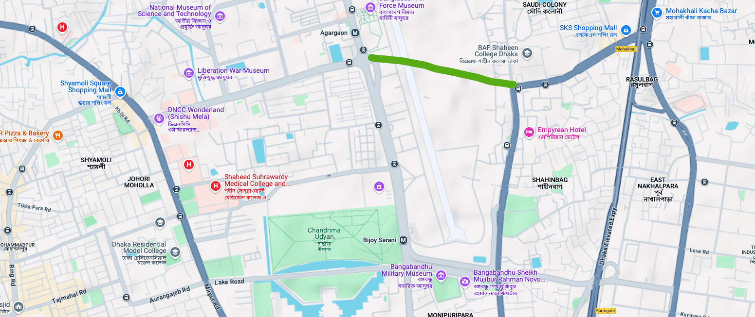
1. Agargaon–Mohakhali: I know, I know, that stupid airport is in the middle, we need to ask why does that airport exist at all to begin with. If we can relocate the Air Force base outside of the city, Agargaon to Jahangir-gate is among the most obvious East-West connections that could significantly reduce the infamous traffic at the Bijay Sarani intersection. As many of those who need to go to Mohammadpur, Kalyanpur, Gabtali area from Mohakhali would go straight towards Shyamoli through this connection.
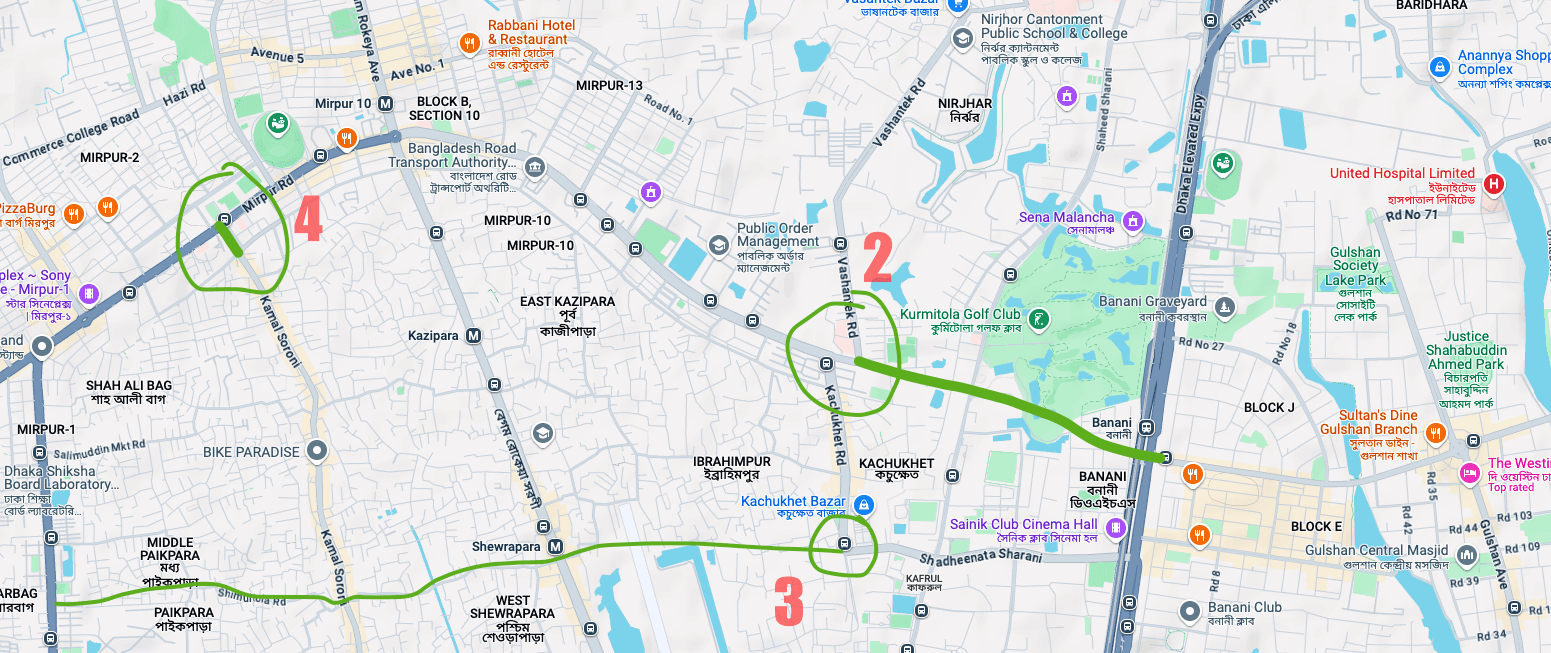
2. Kochukhet–Kakoli: The road from Mirpur-10 intersection to Kochukhet area abruptly ends and haphazardly takes a zigzag left and right turn at the point marked number 2. Whereas the obvious connection could have been going all the way to Kamal Ataturk Avenue meeting at Kakoli intersection. Building this connection does not need much intervention or movement, a big part of it would go through the fringe of Banani DOHS and the Kurmitola Golf Course, it seems quite easy to implement. Only if, only if… you know who should “allow” it to happen.
3. Sainik-Club–Mirpur-1: Then look at this connection marked 3 on the map above, that road from Sainik Club can easily follow it path all the way to Mirpur-1 Darussalam Road. This one wouldn’t be as easy though, it will require some relocations inside Shewrapara and Pikepara area. However, this would significantly improve the connections within those vast organically grown areas.
4. Kamal Sarani’s absurdity: The item marked with 4 on the map, is not an East-West connection, I kept it here to show how many of the absurd designs exists in the city, the 100 feet wide Kamal Sarani abruptly ends before it properly hits the Mirpur Road around Mirpur-2, and then you will have to take some narrow neighbourhood alleyways to crawl through the last few hundred meters to finally connect to Mirpur. It would take relocating only one building there to solve a bottleneck that make thousands of people suffer everyday. Who designed this madness, I wonder!
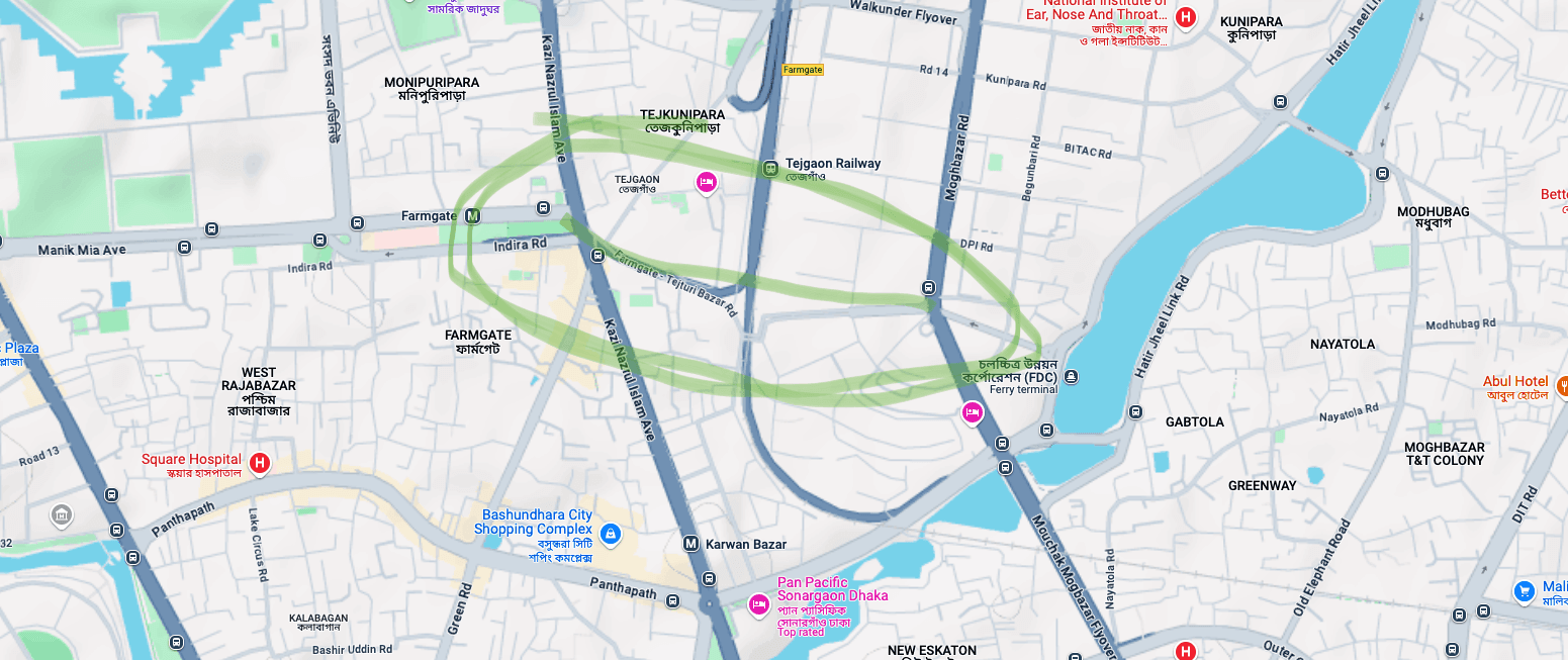
5. Farmgate–Tejgaon: Then look at this craziness! There are so many opportunity to build a clear thoroughfare from Farmgate to Tejgaon, yet these roads are marred in obscurity for no reason. Solving this one should be ridiculously simple, and should come with incredible improvements to traffic of Farmgate and Tejgaon areas.
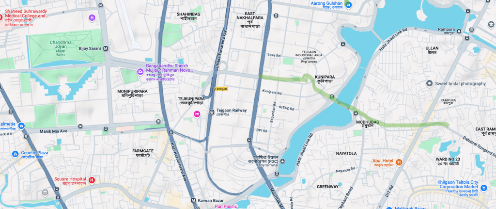
6. Tejgaon–Rampura: Similar to Farmgate–Tejgaon, this one could have easily connected Tejgaon with Rampura, the connection already exists, albeit in a bit uncomfortable tightness at different points—all it needs is improving these tight bottlenecks, and designing the intersections properly where it crosses any other major roads.
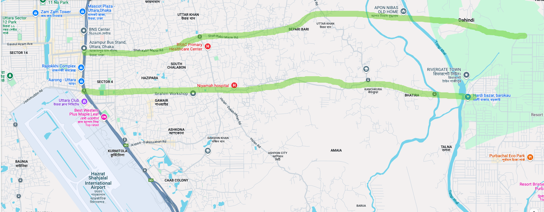
7. Uttara–Purbachal: These two connections are already surfacing organically. We should immediately take the opportunity to build these thoroughfares which would significantly improve the East–West connectivity from the airport and Uttara Sector-4 areas all the way to Purbachal’s northern parts.
These ideas came up just by looking at the map. I am sure, there are several other obvious, and not very difficult interventions that could have been taken to improve Dhaka’s East–West connectivity issues. Big roads on the ground and above are continued to being built in the city, they would have brought better solution only if we could re-orient ourselves to think East–West now!
That being said, these interventions would only add small improvements to the city’s notorious traffic. The real solution still remains in only one statement, reducing traffic is about reducing traffic itself—and that is only possible when we start reducing vehicular traffic by investing in walkability and multi-modal public transport. No number of roads, highways, fly-overs, expressways can ever solve it. New roads could not solve the problems of roads anywhere in the world in history. Just some of these clever interventions can improve the situation around some neighbourhoods and intersections.